South Korea Volcanoes
-

Halla
-
Halla
-
Halla
-
Halla
-
Halla
-
Halla
-
Halla
South Korea has 3 Holocene volcanoes. Note that as a scientific organization we provide these listings for informational purposes only, with no international legal or policy implications. Volcanoes will be included on this list if they are within the boundaries of a country, on a shared boundary or area, in a remote territory, or within a maritime Exclusive Economic Zone. Bolded volcanoes have erupted within the past 20 years. Suggestions and data updates are always welcome ().
| Volcano Name | Location | Last Eruption | Primary Volcano Type |
|---|---|---|---|
| Ch'uga-ryong | Korea | Unknown - Evidence Uncertain | Shield |
| Halla | Korea | 1007 CE | Shield |
| Ulleungdo | Korea | 2990 BCE | Stratovolcano |
Chronological listing of known Holocene eruptions (confirmed or uncertain) from volcanoes in South Korea. Bolded eruptions indicate continuing activity.
| Volcano Name | Start Date | Stop Date | Certainty | VEI | Evidence |
|---|---|---|---|---|---|
| Halla | 1007 | Unknown | Confirmed | Observations: Reported | |
| Halla | 1002 | Unknown | Confirmed | Observations: Reported | |
| Halla | 2050 BCE ± 200 years | Unknown | Confirmed | Isotopic: 14C (uncalibrated) | |
| Halla | 2830 BCE ± 50 years | Unknown | Confirmed | Isotopic: 14C (uncalibrated) | |
| Ulleungdo | 2990 BCE ± 40 years | Unknown | Confirmed | Isotopic: 14C (uncalibrated) | |
| Ulleungdo | 6450 BCE (?) | Unknown | Confirmed | Isotopic: 14C (calibrated) | |
| Ulleungdo | 8750 BCE (?) | Unknown | Confirmed | 6 | Isotopic: 14C (calibrated) |
South Korea has 0 Pleistocene volcanoes. Note that as a scientific organization we provide these listings for informational purposes only, with no international legal or policy implications. Volcanoes will be included on this list if they are within the boundaries of a country, on a shared boundary or area, in a remote territory, or within a maritime Exclusive Economic Zone. Suggestions and data updates are always welcome ().
There are 7 photos available for volcanoes in South Korea.
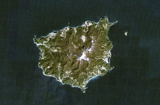 Ulreung stratovolcano forms a small 10-km-wide island about 100 km E of the central Korean Peninsula. The island, seen in this NASA Landsat image (with north to the top) is a tourist destination from the Korean mainland. Ulreung was the site of a major explosive eruption at the beginning of the Holocene that produced pyroclastic flows and deposited ash in central Honshu.
NASA Landsat 7 image (worldwind.arc.nasa.gov)
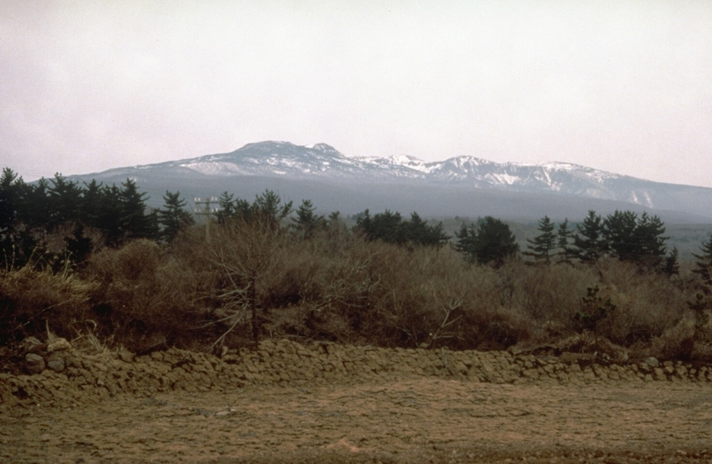
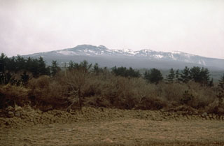
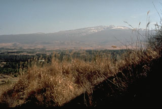 Snow-capped Halla shield volcano is seen here from the north, near Cheju city, the largest on Cheju Island. Voluminous lava flows and an underlying lava plateau form the entire 40 x 80 km island. The volcano is capped by the 400-m-wide Backlockdam summit crater and its flanks contain hundreds of cones, some of which form small offshore islands.
Photo by Norm Banks, 1980 (U.S. Geological Survey).
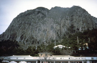 Prominent columnar jointing is visible on the steep sides of a trachytic lava dome on the southern coast of Cheju Island. A cluster of trachytic lava domes were erupted near the end of the second stage of activity of Halla, during which the shield volcano was formed in the center of the island.
Photo by Norm Banks, 1980 (U.S. Geological Survey).
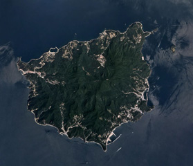 Ulreung volcano forms this small 12-km-wide island about 100 km east of the coast of the central Korean Peninsula. The extensively eroded edifice is seen in this Planet Labs June 2019 satellite image mosaic (N is at the top). It contains a caldera and was the site of a major explosive eruption at the beginning of the Holocene that produced pyroclastic flows and deposited ash across the Sea of Japan.
Satellite image courtesy of Planet Labs Inc., 2019 (https://www.planet.com/).
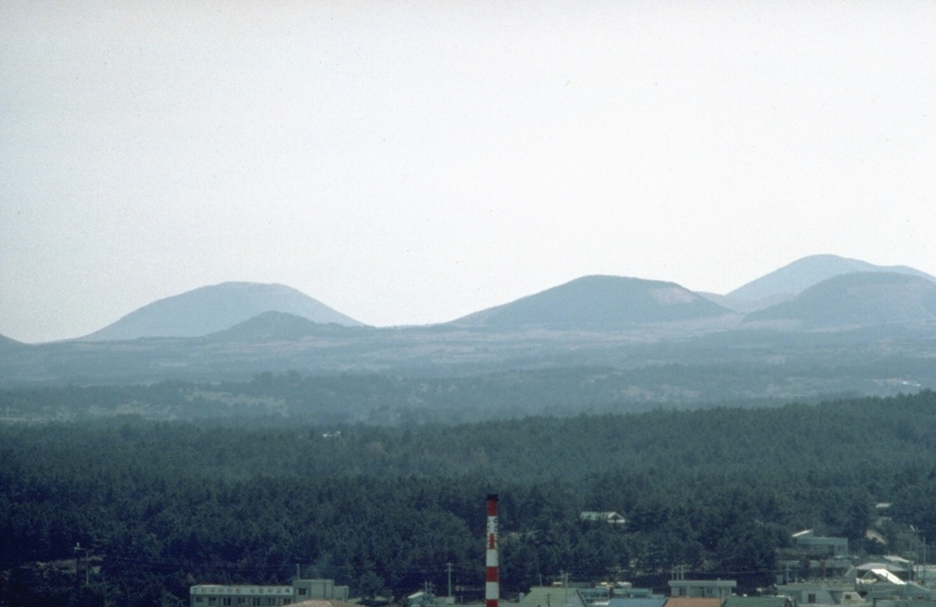
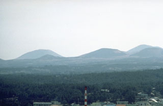 A cluster of scoria cones on the SW rift of Halla shield volcano is part of more than 360 flank cones that were erupted during the third and last stage of activity. Most of the cones were built along the SW-NE-trending rift zone that forms the axis of the island. The basaltic scoria cones are typically 150-200 m in height and are relatively uneroded.
Photo by Norm Banks, 1980 (U.S. Geological Survey).
 The massive Halla shield volcano, seen here from the south, forms much of the 40 x 80 km Cheju Island, which lies 90 km S of the Korean Peninsula. More than 360 late-Pleistocene and Holocene basaltic cones on the flanks of the low-angle volcano were erupted primarily along the long axis of the NE-SW-trending island. Most of these are scoria cones, but about 10 along the coast are Pleistocene tuff rings and tuff cones. Flank eruptions continued into historical time, with the final two taking place during the 11th century.
Photo by Norm Banks, 1980 (U.S. Geological Survey).
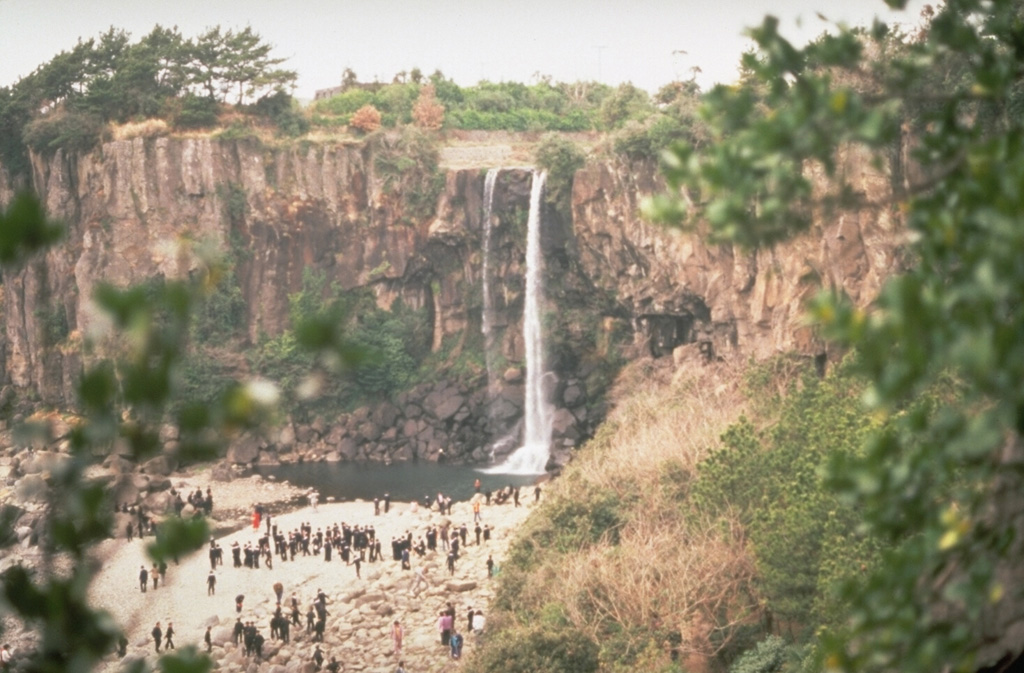
 A waterfall plunging over a trachytic lava flow is a popular tourist destination on Cheju Island. An extensive lava plateau underlies the Halla shield volcano and extends to the coast of the 40 x 80 km island. The volcano dominates the center of the island and has been active from the Pleistocene until historical time.
Photo by Norm Banks, 1980 (U.S. Geological Survey).
This is a compilation of South Korea volcano information sources, such as official monitoring or other government agencies.
| Volcano Observatories | |
|---|---|
| Korean Meteorological Administration (KMA) | |
| Volcanic Ash Advisory Center | |
|---|---|
| Tokyo Volcanic Ash Advisory Center (VAAC) | |
| - Tokyo VAAC Notices and Archive | |